Saving Enlow Valley
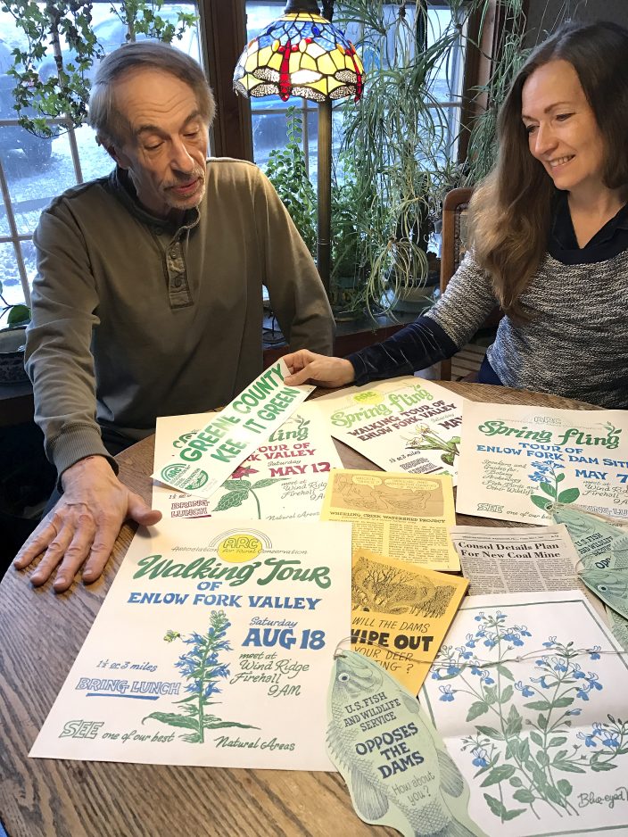
Rick and Marcia Sonneborn of Nebo Ridge look at the posters, bumper stickers, newspaper articles and other memorabilia that they saved from 1979-1986, when the Association of Rural Conservation rallied the community to “Save the Land – Stop the Dams” in Richhill Township.
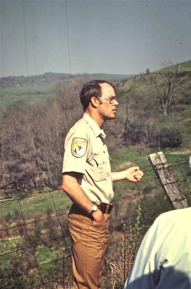
U.S. Fish and Wildlife Services officer Ed Perry speaking at the first walking tour of the Enlow Fork area in August 1979. He’s pictured indicating areas that would soon be impacted by coal mining waste disposal.
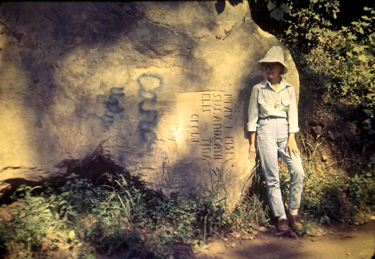
Naturalist and wildlife illustrator Arabelle Wheatley standing beside historic Crow Rock in 1979. Its location was threatened by the proposed duel purpose dam 650 on Dunkard Creek.
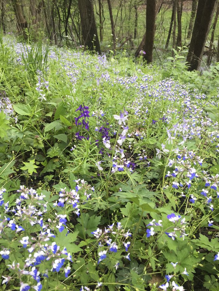
There is a sheltered valley in Richhill Township that is carpeted in early spring with an awesome array of wildflowers, just in time for trout season and the fish that are stocked in its big, meandering stream. Mink and turkey thrive here, and nesting warblers, some rarely seen this far north, sing in the trees. Herds of deer migrate to its sunny slopes from miles around to browse for food during hard winters, and hunters who come to this woodsy corner of Greene County to find trophy bucks can thank this unique valley for what they find.
Thirty-nine years ago, Enlow Valley was slated to become the bottom of a lake that would help process coal for a mine that was yet to be built. But thanks to a community willing to fight to save it, there are still trout to be caught and flowers to be seen.
It was an early spring day in 1978 when local residents Rick and Marcia Sonneborn learned about the proposed dam.
“We were riding our bikes on the road through the valley when we met a man who said, ‘Isn’t it a shame that these beautiful sycamores will soon be covered with water?’ We lived here, and we were clueless,” Marcia Sonneborn remembers.
The man was William Kinney of West Alexander, a member of Western Pennsylvania Botanical Society who brought groups of naturalists every year on the second week of April to see the twinleaf that bloom in mad profusion where the Enlow Fork of Wheeling Creek forms the boundary between Greene and Washington counties.
For 200 years, this western end of Greene County was the place of small towns and farms scattered across the hills and hidden valleys. Those who live here have something in common – they love hunting, fishing, farming and just living on the land they call home.
“We were stunned,” Marcia admits.
The Sonneborns were just married and living on Nebo Ridge, overlooking the threatened valley. They knew that plans were in the works to mine the coal reserves. In time, Consol Energy’s Bailey Mine would be built within miles of their farm and would hire hundreds of local men and women to mine coal and send it by rail to the East Coast. But in 1978, U.S. Steel owned the land and coal rights and was working with the Wheeling Creek Watershed Protection and Flood Prevention Commission to make the best use of the dams that were being proposed to protect Wheeling, W.Va., from cycles of torrential flooding.
The commission was formed in 1967 when Greene and Washington counties joined with representatives from Ohio and Marshall counties in West Virginia to plan a series of dams to protect downstream residents. The commission was tasked with implementing the dams, and the counties involved put aside funds to build them. But in the decade that followed, the cost estimates of 1967 lagged behind inflation, and the money set aside was not enough to do the job. That – and a lack of communication about what the commission was proposing – would eventually lead to even more problems with the public at large.
The first letter to the editor was written to the Observer-Reporter in 1978 and signed by Richhill Township supervisor Harold Finnegin, Rick Sonneborn and Joe Adler, another resident who was concerned about the loss of so much productive and environmentally valuable land. According to Sonneborn, the letter spelled out what the community found so wrong with building two dual purpose dams in Richhill Township as part of Wheeling’s flood-control plan. Dams 648 and 650 were being touted as creating lakes that would be recreational, as well as protecting those downstream from the floodwaters that the big watershed coming out of Greene County could generate. Part of the agreement also stated that U.S. Steel would have first use of the waters behind Dam 648 on Enlow Fork for its yet-to-be-built Manor Mine.
“It seemed to us that it was very good for land speculators who heard about it first and were buying up lots along the banks of the lakes. Plus, the coal company was getting the taxpayers to pay for helping build their containment pool and maintaining it for years to come,” Rick says. But for the residents of Crabapple, including the Crow family who lived along the banks of Dunkard Creek, farther west where the second Dam 650 was to be built, it would mean losing their homes and their land, some dating to the 1700s when Greene County was the Western frontier. The “Crow Massacre” rock that stood where three Crow sisters died May 1, 1791, would have to be moved or history would be lost. Dam 648 would displace fewer families, but the site’s natural habitat was too unique to let go without a fight.
Finnegan, along with fellow supervisors Ray Whipkey and Paul Day, joined with residents to form the Association for Rural Conservation – ARC, with a mission to “save the land, stop the dams.”
After that first letter to the editor, “a lot more people started writing,” Rick notes.
Members of ARC began attending meetings and public hearings, and soon ARC would have 300 people in its ranks, including Ed Perry of the U.S. Fish and Wildlife Service and Lawrence Strickling, a Chicago lawyer who married into the Crow family and learned about the potential loss of land when visiting for a family reunion. Arabelle Wheatly, a relative of the Dinsmore family and a professional illustrator who owned land near her family home in Richhill Township, became the one to add art to the effort, doing multicolor block prints of the flowers of Enlow to show the public the beauty of what was about to be lost.
This was the beginning of a three-year push to build single-purpose dry dams, the option that ultimately was pursued. By 1980, Marcia Sonneborn was president of ARC. She still has boxes of records and news clippings along with vivid memories of the people who became friends while working together to save their land.
ARC published a newsletter to keep the public informed and led a walk in August 1979 to tour the proposed dam site. On May 3, 1980, ARC held its first Spring Fling with experts from regional botanical societies leading tours. The Paul R. Stewart Archaeology Society from Waynesburg College showed where indigenous tribes once lived. Local ornithologist Ralph Bell helped identify the warblers and other nesting birds, and more than 100 people came to listen and learn.
The public meeting at the Wind Ridge fire hall held by the Wheeling Creek Commission three days later was packed. Some who attended were bused in from West Virginia to testify about the need for flood control. Others were there to state their opposition to the economic, cultural and environmental costs of “wet dams.”
That year, members of ARC demonstrated in front of U.S. Steel’s offices in Pittsburgh with a live turkey, urging the company to rethink its plans to leave the public footing the bill for maintaining the dam that would give the company water for its mine. But there were other economic forces at work. U.S. Steel was preparing to get out of the business of coal and already was in the process of selling and leasing its assets.
According to an ARC newsletter dated December 1980, U.S. Steel had announced plans to sell its mining options to Consolidation Coal, now known as Consol Energy, and would no longer be part of the dam project.
As the Wheeling Creek Commission grappled with the economics of the dams and dealt with public pushback, it voted in January 1981 in favor of dry dams, which offered waterways beneath them to allow floodwaters to be retained, then gradually released.
ARC applauded this decision but continued its efforts to ensure that the dry dams did as little environmental harm as possible for the next four years.
Dry dam 648 was finished downstream, just above Majorsville, in 1986, a year ahead of schedule.
According to an editorial in the Observer-Reporter, plans for a single purpose dry dam near Crabapple and Crow Rock were shelved in 1985, and it ended up being built in West Virginia, making it the seventh dam in the project to protect Wheeling.
Once threats to their land were gone, ARC activists went back to living their lives, secure in the knowledge that the land they loved had been saved for their children to enjoy.
Every spring, people still trek to the valley below Nebo Ridge to see the carpets of blue-eyed Mary, listen for the warblers and do some fishing. Nebo Ridge itself is now crisscrossed with the effects of mining that is ongoing at Bailey Mine, and those who take a side tour can see the nearby valley that has been used to deposit waste from 30 years of mining activity.
The drive into the valley goes through the facility that was built to transport coal to the railroad, but then the gravel road drops into the quietude of what is now State Game Lands 302, its steep ravines still dripping with flowers and its stillness broken only by the sound of running water.
Enlow Creek has broad riffles with a rich variety of macroinvertabrates, but stretches of its waters also flow slowly through muddy pools where the subsidence from longwall mining dropped the creek bed two to three feet, allowing silt to settle and the water to become less oxygenated.
The walks are now sponsored by the Wheeling Creek Watershed Conservancy, which formed in 2000 to draw attention to perennial streams threatened by longwall mining and to bring together area landowners who deal with the effects of mine subsidence on their springs, wells and streams.
This year’s spring wildflower and bird walk is April 30. Directions and more information can be found at enlowfork.tripod.com.