When woods surrounded Woodside
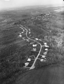
Woodside Drive in South Strabane Township, two miles east of the center of Washington as the crow flies, was aptly named. When houses started to be built along it in the early 1950s, there were deep woods on either side of the meandering road. It continued to be sheltered by forest into the early 1960s, when this aerial photograph was probably taken.
In the past 50 years, however, the landscape has changed dramatically. Housing developments like Windsor Highlands replaced farmland and timber, and the township’s population exploded.
We thought this week’s Mystery Photo would be a challenge for readers to identify, but we were wrong. We received more than two dozen emails and phone calls from the public, some of whom recognized the rooftops of their own houses.
“I grew up in the house on bottom left of the photo,” wrote Debi McClay Nicolella. “It was really great to see this picture, and I can’t wait to send it to my parents!”
Lynn Hall-Lazaroff recognized her house, built in 1958, and Kate Corwin believes her house, built in 1964, is in the picture as well. Becky Devore was born in 1959 and grew up on Woodside Drive. She was able to name nearly all the families who lived along the road. She remembers riding her horse in the woods and the field at the bottom of the photo, and, “in the woods to the right of Woodside Drive you can see a small pond that we skated on as children.”
The tall structure at upper right is a water tower, and the buildings near it were Warrick’s Nursery.
Aaron Stimmel bought the property in 1974 and has operated the greenhouses there ever since.
The most important clue in the photo is the tiny white rectangle in the distance. It is the screen of the Route 19 Drive-in, on land now occupied by Washington Ford. The theater operated into the mid-1970s.
We are grateful to several readers who sent us current satellite images of the same area to verify the location. One of them was Alan Finder, a 1970 Trinity High School graduate now living in Winchester, Mass. He concluded the photo was taken in the early 1960s and said it might have had something to do with the alignment of Interstate 70 relative to Lakeview Drive, which parallels Woodside.
“My father, Sanford Finder (now deceased), told me the alignment was ultimately shifted across Lakeview Drive to its present-day alignment. The decision reduced the cost of acquiring rights of way by avoiding the need to pay to displace so many valuable real estate parcels.”
Good thing for Woodside Drive residents the highway between the north and south junctions did not follow its originally planned course. Otherwise, they’d be living on Interstateside Drive.
Look for another Mystery Photo in next Monday’s Observer-Reporter.