Island refuge stretches over 362 miles
WILLIAMSTOWN, W.Va. – West Virginia’s first national wildlife refuge is not vast in terms of land mass, encompassing only 3,440 acres, or a little over five square miles.
But when that land is broken into 22 islands and four patches of shoreline along a 362-mile stretch of river extending into three states, it takes up a lot of map – and poses some major logistical challenges to the refuge’s seven-person full-time staff.
“When you’re dealing with a chain of islands stretching almost from Pittsburgh to Cincinnati, managing them is not easy,” said Glen Klingler, manager of the refuge.
The Ohio River Islands National Wildlife Refuge was formed in 1990 to “fulfill the needs of fish, wildlife and plants that are native to big river ecosystems” while preserving and enhancing “a quality river environment for the people of the Ohio River Valley,” according to its mission statement.
All but four of the 22 islands are found within West Virginia’s section of the Ohio River. Two refuge islands each are located in Kentucky and Pennsylvania waters.
Former U.S. Fish and Wildlife Service biologist Bill Tolin, who grew up along the river in Ohio and worked at agency offices in Huntington and Elkins, is credited with being the person to first envision creation of the refuge. In the 1980s, he cataloged the wide range of flora and fauna found on, and in the waters off, the dwindling number of islands existing within the upper half of one of the nation’s busiest waterways.
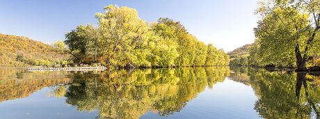
The islands, threatened by erosion and mining by sand and gravel companies, are home to some of the region’s best-preserved remnants of bottomland hardwood forests. Mature stands of trees within the forest provide nesting and roosting habitat for eagles, osprey and herons, sometimes within sight of large power or chemical plants. The bottomland forests also contain the proper canopy structure to support at least 25 species of warblers and several types of bats.
In all, more than 200 types of birds use the refuge during the course of a year, including 25 species of waterfowl. The refuge is also home to at least 25 species of mammals, ranging from mink and meadow jumping mice to woodchucks and white-tailed deer.
“Some of the biggest deer you’ll ever find are on these islands,” said Klingler, refuge manager. While archery deer hunting is allowed on refuge islands by permit, “hunters face a lot of hard walking through thick vegetation” to come within range of their targets, Klingler said.
On refuge islands where farming or logging has occurred, plantings of native trees have taken place, and natural succession has been encouraged.
The sand and gravel that made the islands attractive to dredge operators working in behalf of paving companies also make the waters surrounding the islands an attractive habitat to more than 100 varieties of fish and 40 species of mussels, including six that are endangered.
“The mussels aren’t warm and fuzzy – they’re not panda bears – but we’re responsible for protecting them,” said Sara Siekierski, assistant refuge manager.
Since 2007, the refuge has been involved in a restoration project focusing on nine species of native mussels. The refuge staff has also been monitoring the spread of the zebra mussel, an invasive species that began entering the Ohio River system in the early 1990s.
While zebra mussel populations of up to 10,000 per square meter turned up at a monitoring site in Wood County in 1999, the zebra numbers fell off dramatically the following year, and have fluctuated since.
Klingler and Siekierski said refuge biologists have seen a decline in zebra mussel numbers in the last couple of years. Die-offs of the invasive mollusk can occur when river temperatures approach 80 degrees, or when high water events scour river bottoms, they said.
Concentrated populations of zebra mussels can kill native mussel species, since the invasive shellfish can attach themselves to the shells of the native mussels and cut off their access to food and oxygen.
While native mussels living on the refuge may be seldom seen by human visitors, they play an important role in river ecology. A bed of 200,000 mussels can filter 1 million gallons of water a day.
But plants and animals aren’t all the refuge’s staff is charged with protecting. The refuge’s namesake islands face threats from erosion from floods and wave action from river traffic. To stabilize them, the refuge, in partnership with the U.S. Army Corps of Engineers, has installed longitudinal rock dikes on a number of refuge islands, including Buckley Island, which fronts the refuge’s headquarters building near Williamstown.
“We’re seeing some pretty immediate results from the dikes,” said Klingler.
The rock dikes, installed at intervals along an island’s shoreline, extend a short distance into the Ohio River, trapping sediment behind them.
“Willows start growing in the silt behind the dikes in no time,” Klingler said, and other plants follow suit.
Other threats to the refuge’s islands and shoreline tracts include an array of invasive plants, including Japanese knotweed, giant hogweed, mile-a-minute weed, autumn olive and multiflora rose.
Efforts to control invasive plants are now done sporadically, and Klingler said, “We need to come up with a management plan.”
Oil drilling occurred on some Ohio River islands in the decades before they became part of the national wildlife refuge system. While the refuge has removed a number of pumps, pipes and related infrastructure from the islands, it may face new challenges from natural gas development in the region, since it doesn’t own the mineral rights to all of its land.
“The interest in Marcellus gas and horizontal drilling will probably become an issue here at some point,” Klingler said.
In recent years, a number of developments have improved access to, and understanding of, the refuge. First and foremost was the 2008 opening of the refuge’s visitor center and headquarters complex on Waverly Road, a short distance upriver from Williamstown.
The visitor center includes a 1,200-gallon aquarium containing examples of fish, mussels and other forms of aquatic life living in refuge waters, and exhibits detailing the islands’ human history and plant and animal life. Unfortunately, the aquarium and several of the exhibits are now closed to accommodate repairs following a water pipe break.
An array of solar panels supplies a portion of the visitor center’s electrical needs, and the building makes use of geothermal component to its heating and cooling system.
Adjacent to the visitor center, 1.5-mile-long Upland Trail loops up a forested hill, and half-mile-long Riverview Trail takes visitors along the shore of the Ohio to fishing access points in a shoreline habitat restoration area. A canoe and kayak boat launch area and dock opened at the visitor center earlier this year.
Middle Island near St. Marys is probably the most visited island in the refuge, since it is one of only two islands that can be reached by bridge. The other bridge-accessible refuge property is a shoreline section of Ohio County’s Wheeling Island.
On 240-acre Middle Island, visitors can drive along a 1.6-mile “Auto Trail,” equipped with pull-off areas and interpretive signs, or hike 3.5 miles of trails, including a barrier-free trail that leads to a wildlife viewing blind overlooking a small wetland.
The refuge is currently considering allowing commercial outfitters to lead birding and wildlife-watching paddling tours of several refuge islands accessible only by boat.
The refuge opened in 1990 when eight islands, bought with assistance from The Nature Conservancy. Long-range plans call for bringing the total number of islands up from the current 22 to as many as 38, through purchases from willing sellers.
But, given current budget constraints, which include the loss of an office administrator’s position due to sequestration, “It’s unlikely we’ll be adding any more islands in the near term,” Klingler said. ?Comments by Klinger and Siekierski were made during a visit to the refuge by those taking part in the West Virginia Highlands Conservancy’s “This Land Is Your Land” program. So far this year, the “This Land Is Your Land” program has visited Canaan Valley National Wildlife Refuge, the Monongahela National Forest, and Canaan Valley State Park. On Sept. 8, starting at 1 p.m., a visit is planned for Kanawha State Forest, and on Oct. 6, a visit to the Monongahela National Forest’s Bartow Ranger District is scheduled.
“The idea is to give people a better understanding of the different interests and the different laws that are involved with the various agencies managing public lands,” said Dave Saville, chairman of the conservancy’s public lands committee. “Above all, the idea is to show that these lands are managed by people, many of whom bring a lot of expertise to their jobs. In my opinion, we can benefit a lot more by working with them than fighting them.”